Hands-on Floodplain Education with NMFMA
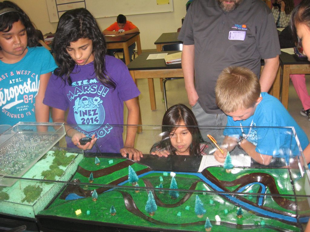
On October 7 and 8, 2014, NMFMA brought the Floodplain Simulator to Madison Middle School in Albuquerque NM. The Floodplain Simulator was shown to 10 classes of 6th grade earth science students. Each class was roughly 30 students..
In preparation for the visit, Mr. Sean O’Melveny, corresponded with Mr. Nicholas Porter and Mrs. Chanel Bencomo; both 6th grade science teachers at Madison to set up the visit and set expectations. As part of the preparation for having the Floodplain Simulator in the class, Mr. Porter and Mrs. Bencomo discussed some of the terms used in floodplain management with the students. This was done by using the glossary of terms provided with the Floodplain Simulator. The day before preparation some discussion of the recommended classroom activity #2 “The Fate of Rain” from Flood Model Manual provided with the Floodplain Simulator. The students also watched a brief video from the Discovery Channel on flooding. Mr. Porter also prepared a word search and crossword puzzle using terms from the glossary.
On October 7, 2014, the Floodplain Simulator visited Mrs. Bencomo’s 5 classes. On October 8, 2014 the Floodplain Simulator visited Mr. Porter’s 5 classes.
Typical Class period went as follows:
The teacher briefly introduced Mr. O’Melveny and broke each class into groups of five to six students. Mr. O’Melveny then asked the students some questions about what they remembered from the previous day’s discussions and pointed out features on the model. Mr. O’Melveny related the model to the real world watershed of students attending Madison.
Then Mr. O’Melveny called each group up to do part of the recommended classroom activity #3 “Modeling Flood Risk Factors”. One or two groups would run the “wetlands headwater scenario”, while the other groups conducted the “parking lot headwater scenario”. Mr. O’Melveny assigned group members had the following responsibilities
- Data Recorder: who filled out the Gage Height, Rainfall Added and Runoff measurements for the group’s assigned scenario from the Data Recorder Sheet which was provided.
- Timer: who called out the 5 second intervals for recording data
- River Reader: who called out the gage height when prompted by the Timer
- Rainmaker: who measured out the Rainfall added amount and poured the water into the rainmaker. This group member also provided some general observations of the experiment
- Drain Watcher: who made sure no homes or trees got stuck in the drain/outlet of the model. They also provided some general observations of the experiment. At the end of the 2-3 minutes of model run, this group member also measured out the Runoff measurement
- General Observer (as needed): Some groups had an extra person and this person provided some general observations of the experiment to the whole group.
Following each run, Mr. O’Melveny and the teachers had the group determine the Amount of Water that stayed in the model and the Runoff Footprint. The group also discussed the general observations made.
While students were waiting on their turn at the model, they worked on the flooding word search and crossword puzzle that Mr. Porter had created.
After all 5-6 groups per class had participated, Mr. O’Melveny then had the groups present their results. This lead to a general discussion on how the two headwaters were different and how that affected flooding.
Following this general discussion Mr. O’Melveny presented a final run of the parking lot scenario to the whole class, so all students could see the model in action.
After this demonstration, Mr. O’Melveny lead the class in possible ways to mitigate flood hazards. The main ideas brainstormed by the students were:
- Not build in the floodplain (build homes higher in the model)
- Build the house on stilts or other ideas to elevate the structure
- Build Dams, Ponds, etc to collect the water
- Build Canals, Moats, Ditches to divert the water
- Build levees or place sandbags
Mr. O’Melveny then passed out cards to NMFlood.org to interested students so that they could learn more.
Other items to note:
Mr. Porter had a projector which would capture the events inside the model from a bird’s eye view and show them on a screen so the whole class could see what was happening. This was extremely useful to allow some students to see what was going on.
Mr. Porter’s 5th period class was smaller than the other classes. With this extra time the “retention pond scenario” from recommended classroom activity #4 was also demonstrated.
Mr. Porter’s 6th period class reviewed the National Flood Hazard Layer in Google Earth to see what flood hazards impacted Madison. It was discovered that the Science Building of the Middle School is actually in a Zone AO floodplain. It was also pointed out where a retention pond was located next to the school. This exercise helped bring the discussion home to the students.
As a follow-up activity, Mr. O’Melveny made Hydrograph Worksheet available to Mr. Porter and Mrs. Bencomo so that the students could graph their results.


Leave a Reply
Want to join the discussion?Feel free to contribute!